
Jaguar Uranium Reports Final Uranium Assay Result From Huemul Uranium-Copper-Vanadium Project of 4.21% U₃O₈
PR Newswire
TORONTO, Oct. 6, 2026
- Over-limit reanalysis of selective outcrop composite sample 4319 returned 4.21% U3O8 (equivalent to 3.57% U).1
- Updated channel and rock chip sample assay results containing copper (up to 8.54%), uranium oxide (up to 4.21%), silver (up to 708 g/t) and vanadium oxide (up to 2.27%)2.
- Sampling of strike extensions along the Uryco/Rosa and Black zone trends has identified copper-bearing surface occurrences within a greater than four-kilometre-long exploration corridor.3
Table 1 Selected samples containing either U3O8 above 5,000 ppm or Cu above 2.0%:
|
Sample ID |
Ag (ppm) |
Cu (%) |
U3O8 |
V2O5 |
Sample ID |
Ag (ppm) |
Cu (%) |
U3O8 |
V2O5 |
|
|
4247 |
95 |
2.30 |
183 |
80 |
4348 |
13 |
4.48 |
238 |
68 |
|
|
4257 |
64 |
4.04 |
321 |
195 |
4358 |
12 |
2.78 |
189 |
105 |
|
|
4277 |
31 |
0.29 |
10,577 |
3,570 |
4359 |
10 |
3.68 |
93 |
82 |
|
|
4278 |
32 |
1.24 |
6,450 |
6,927 |
4365 |
<5 |
8.54 |
26 |
198 |
|
|
4290 |
79 |
0.84 |
26,768 |
16,085 |
4366 |
<5 |
4.33 |
31 |
82 |
|
|
4291 |
105 |
0.27 |
24,409 |
12,621 |
4372 |
<5 |
2.35 |
29 |
154 |
|
|
4292 |
45 |
0.17 |
24,174 |
12,853 |
4374 |
5 |
2.20 |
74 |
89 |
|
|
4293 |
17 |
0.23 |
9,905 |
6,516 |
4375 |
5 |
3.05 |
71 |
77 |
|
|
4296 |
133 |
2.04 |
16,922 |
12,978 |
4384 |
<5 |
2.37 |
11 |
79 |
|
|
4297 |
212 |
0.42 |
17,983 |
9,515 |
4400 |
10 |
2.05 |
111 |
54 |
|
|
4298 |
85 |
0.23 |
21,579 |
13,996 |
4403 |
27 |
3.66 |
91 |
86 |
|
|
4319 |
210 |
1.62 |
42,097 |
22,672 |
4405 |
38 |
4.37 |
377 |
91 |
|
|
4325 |
8 |
2.08 |
53 |
86 |
4408 |
21 |
5.11 |
284 |
161 |
|
|
4328 |
<5 |
3.39 |
61 |
134 |
4423 |
17 |
4.27 |
31 |
114 |
|
|
4333 |
15 |
2.02 |
61 |
68 |
4424 |
8 |
3.11 |
15 |
100 |
|
|
4335 |
62 |
5.78 |
164 |
96 |
4425 |
<5 |
2.20 |
5 |
71 |
|
|
4344 |
<5 |
3.82 |
145 |
80 |
TORONTO, Oct. 6, 2026 /PRNewswire/ — Jaguar Uranium Corp. (NYSE-AM: JAGU) (“Jaguar” or the “Company”) is pleased to announce an additional high-grade uranium assay from its initial rock sampling program at the Huemul Uranium-Copper-Vanadium (U-Cu-V) Project in Malargüe, Mendoza Province, Argentina. The Company previously reported initial sampling results on July 20, 2026 and August 18, 2026, with the latest assay representing a new over-limit uranium sample received from the program. The sample returned 4.21% U₃O₈ (3.57% U), exceeding the laboratory’s upper reporting limit of 25,000 ppm uranium.
The Huemul Project covers more than 27,000 hectares in the Huemul district and includes a past-producing uranium mine. The results of the current sampling program will be used to support ongoing target evaluation as the Company considers the potential for a maiden drill campaign at the Project.
|
___________________________ |
|
1 The sample does not represent a channel width and may not be representative of average grade or continuity. |
|
2 Because sampling was selective and targeted areas of visible mineralization, the results may be biased high and should not be considered representative of grade distribution, continuity or mineralization across the Huemul ProjectOne. |
|
3 The occurrences have not been demonstrated to form a continuous mineralized zone. |
Management Commentary
“We are encouraged by this latest high-grade uranium result from Huemul, which provides further evidence of the strength of the uranium system we are seeing at surface. A result of 4.21% U₃O₈ is particularly significant as we continue to advance our understanding of the Project and plan the next steps in our exploration program. These results are helping us refine our exploration priorities and identify the areas with the greatest potential for follow-up work.” said Steven Gold, President & Chief Executive Officer.
A District with Documented Historical Production
The Huemul Project is anchored by Argentina’s first-ever producing uranium mine, commissioned in 1955 and operated continuously until 1975 by the Comisión Nacional de Energía Atómica (CNEA). Historical records report that approximately 130,000 tonnes of mineralized material, historically described as ore, were processed at the Malargüe plant, with reported average head grades of 0.21% uranium, 2.0% copper and 0.11% vanadium (source: Guillermo Rojas, 1999. Distrito Uranìfero Pampa Amarilla, Mendoza. En Recursos Minerales de la Republica Argentina. Pag.1135-1140). The Company has not independently verified the historical production records or historical head-grade information, and such information should not be interpreted as current exploration results, a mineral resource estimate, a mineral reserve estimate or evidence of current economic viability. The historical information is considered relevant because it indicates the presence of uranium-copper-vanadium mineralization within the Project area.4
The project hosts uranium-copper-vanadium mineralization in a classic sandstone-hosted deposit setting. The broader Malargüe Mining District remains largely untested by modern exploration methods. Based on the presence of a former producing mine, historical exploration data, and the extent of the Company’s land package, management believes the project warrants further systematic exploration.
|
____________________________ |
|
4 Additional work would be required to verify the historical information and determine its relevance to current exploration results. |
Sampling Program and QA/QC
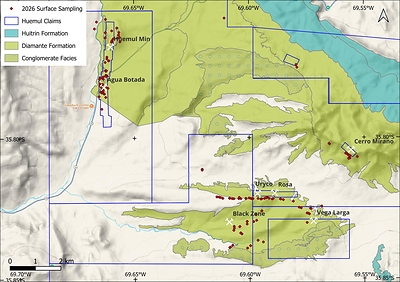
Jaguar conducted targeted sampling that included outcrop, subcrop, rock chip composite, channel and float samples, across areas of visible surface mineralization. Field observations were generally consistent with the presence of mineralization described in historical reports, particularly around the former Huemul mine, as described previously here. Samples were collected from eight target areas, namely, Huemul Mine, Agua Botada, Uryco, Rosa, Vega Larga, Black Zone, Cerro Mirano and Lucy (Figure 1).
Channel samples were collected over intervals ranging from 50 cm to 280 cm. All samples were packaged and sealed at the project site by Jaguar geologist and transported to ALS in Mendoza, Argentina for analysis using sodium peroxide decomposition method ME-MS89L™. ALS Mendoza is a full-service laboratory and is ISO/IEC 17025 accredited sample preparation and geochemical analysis. ALS Mendoza is independent of Jaguar.
Jaguar included 6 Blanks and 6 Duplicates as part of the sample submission (200 samples in total) for QA/QC assessment. Blank material performed satisfactorily. Two duplicate samples did not compare well and were subsequently re-analysed. The re-analysis confirmed the original assay values for those samples. The QP has reviewed the QA/QC results and affirms that the assay results suitable for disclosure as Exploration Results.
Since the sampling of visible mineralization is selective by nature, the exploration results disclosed in this news release are potentially biased and do not establish the extent and continuity of grade, tonnage, economic significance, mineral resources or mineral reserves of the Huemul Project.
Huemul Mine / Agua Botada Trend
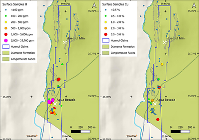
The Huemul Mine / Agua Botada Trend represents a predominantly uranium-vanadium mineralized zone. Mineralization is hosted in the Diamante Formation sandstones, conglomerates, shales and volcaniclastics striking north-south and dipping 20-25° to the west in the north and becoming flat lying to the south. Recent sampling results appear to show the dominance of U over Cu in this area (Figure 3).
Uryco-Rosa, Black Zone and Vega Larga Trend
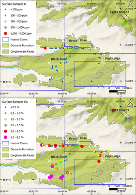
The Cerro Mirano, Uryco-Rosa, Black Zone and Vega Larga areas are dominated by Cu-U-V±Ag mineralization. Mapping, rock sampling and gamma surveying have delineated the Uryco-Rosa, Black Zone and Vega Larga target areas, with apparent strike lengths of approximately 2,200 m, 1,300 m and 2,300 m, respectively, hosted along conglomerate and sandstone horizons of the Diamante Formation that collectively define a greater than 4 km corridor of mineralized occurrences. The Cerro Mirano mineralized zone is related to the intrusion of andesitic dikes and is approximately 300 m long. Recent sampling results appear to show the dominance of Cu over U in this area (Figure 3).
Since the sampling of visible mineralization is selective by nature, the exploration results disclosed in this news release are potentially biased and do not establish the extent and continuity of grade, tonnage, economic significance, mineral resources or mineral reserves of the Huemul Project.
Data Verification
The QP’s review of the sampling, analytical and QA/QC information disclosed in this news release was limited to a review of information provided by the Company and its consultants, including sample locations, sample descriptions, analytical certificates, analytical methods and QA/QC results. The QP has not completed a current site visit to the Huemul Project and has not independently observed or physically verified the sampling procedures, sample locations, sample security or chain-of-custody procedures. The QP has not independently verified the historical production, historical grade or historical exploration information referenced in this news release. The QP’s review is subject to the limitations described herein, including the selective nature of the samples.
Over-limit samples for copper (indicated as >25000) were re-analysed by ALS using 4 acid digest and ICP finish (ME-OG62™). One over-limit sample for uranium (indicated as >25000) was re-analysed using XRF for base metal ores by fusion (ME-XRF15b™). Duplicate re-analysis confirmed the original assay results that were received and indicates a potential sample swap, either during project preparation, or at the laboratory. In the opinion of the QP, these issues are not material at this stage of the project but will need closer attention during further work phases.
Cautionary Note
The Huemul Project is an exploration-stage property. No mineral resource or mineral reserve estimate has been prepared for the Huemul Project under National Instrument 43-101 — Standards of Disclosure for Mineral Projects (“NI 43-101”) or Subpart 1300 of Regulation S-K. The surface sampling results disclosed in this news release are Exploration Results only and should not be interpreted as establishing the presence of mineral resources or mineral reserves. Rock chip and channel samples are selective by nature and may not be representative of mineralization across the property.
Historical production, grade and exploration information referenced in this news release is historical in nature and has not been independently verified by the Company or by a Qualified Person under NI 43-101 or Subpart 1300 of Regulation S-K. The Company is not treating this information as current mineral resources, mineral reserves, or current exploration results. The information is considered relevant because it indicates the presence of uranium-copper-vanadium mineralization on the property, but it should not be relied upon until confirmed by additional exploration work.
Qualified Person
The scientific and technical information contained in this news release has been reviewed and approved by George van der Walt, Pr.Sci.Nat., an independent Principal Consultant with The MSA Group (Pty) Ltd., who is a Qualified Person under NI 43-101 and Subpart 1300 of Regulation S-K. Mr. van der Walt has reviewed the sampling, analytical and QA/QC information disclosed in this news release on the basis of information provided by the Company and its consultants and has approved the technical disclosure in the form and context in which it appears. Mr. van der Walt has not completed a current site visit to the Huemul Project and has not independently observed or physically verified the sampling procedures or sample chain of custody.
About Jaguar Uranium
Jaguar Uranium Corp. is a South America-focused uranium exploration company advancing a portfolio of prospective brownfield projects across Argentina and Colombia. In Argentina, Jaguar is advancing the Laguna Salada Project in Chubut Province and the historic Huemul uranium mine in Mendoza Province. Anchored by a former producing mine, a historic uranium district and exploration projects supported by historical drilling, the Company is focused on advancing and expanding uranium opportunities across the region. The Company’s Berlin Project in Caldas Province, Colombia is a district-scale, sedimentary-hosted polymetallic system historically reported to host uranium alongside rare earth elements, vanadium, nickel, phosphate, molybdenum, rhenium and zinc. Jaguar completed a $25 million initial public offering on NYSE American in February 2026 and is led by an experienced team with backgrounds in exploration, permitting, project development and mining finance in South America.
Forward Looking Statements
This news release contains “forward-looking statements” within the meaning of applicable U.S. and Canadian securities laws. Forward-looking statements are statements that are not historical facts and include, without limitation, statements regarding: the interpretation of exploration results; the potential extent, continuity, and significance of observed mineralization; the identification of prospective target areas; the potential for discovery; planned or future exploration programs; and the Company’s expectations regarding the Huemul Project and the broader Malargüe district.
Forward-looking statements are based on a number of material assumptions, including, but not limited to: the accuracy of historical data; the reliability of sampling and field observations; the continuity of mineralization observed at surface; the availability of financing and personnel; the availability of equipment, laboratory capacity, property access and required permits; and the Company’s ability to execute its exploration plans as currently contemplated.
Forward-looking statements are subject to known and unknown risks, uncertainties and other factors that may cause actual results to differ materially from those expressed or implied by such statements. These risks and uncertainties include, among others: risks relating to the interpretation of exploration results; risks that duplicate-sample reanalysis or additional QA/QC review may affect the interpretation of results; the possibility that mineralization is not continuous or of economic grade; risks associated with early-stage exploration properties; the selective nature of rock chip, channel, composite, select and mine-dump samples; reliance on historical data that may be incomplete or inaccurate; commodity price volatility; permitting and regulatory risks; operational and technical risks; and general economic, market and industry conditions.
Forward-looking statements speak only as of the date of this news release. Except as required by applicable securities laws, the Company undertakes no obligation to update or revise any forward-looking statements to reflect events or circumstances after the date of this release or to reflect the occurrence of unanticipated events.
APPENDIX 1: Full tabulation of final sample assay results
|
Sample ID |
Easting |
Northing |
Sample Type |
Channel |
Channel |
Ag (ppm) |
Cu (%) |
U3O8 (ppm) |
V2O5 (ppm) |
|
4226 |
2440636 |
6042968 |
Outcrop Chip |
<5 |
0.002 |
4 |
107 |
||
|
4227 |
2440703 |
6042691 |
Subcrop Channel |
160 |
250 |
<5 |
0.002 |
1 |
129 |
|
4228 |
2440703 |
6042691 |
Subcrop Channel |
80 |
250 |
<5 |
0.003 |
2 |
316 |
|
4229 |
2440718 |
6042793 |
Outcrop Channel |
100 |
<5 |
<0.002 |
3 |
155 |
|
|
4230 |
2439837 |
6043204 |
Outcrop Channel |
140 |
250 |
<5 |
<0.002 |
2 |
18 |
|
4231 |
2439756 |
6042929 |
Outcrop Channel |
120 |
0 |
<5 |
<0.002 |
2 |
86 |
|
4232 |
2440192 |
6043308 |
Outcrop Composite |
<5 |
<0.002 |
5 |
25 |
||
|
4233 |
2440183 |
6042783 |
Outcrop Channel |
200 |
270 |
<5 |
<0.002 |
2 |
62 |
|
4234 |
2440176 |
6042580 |
Outcrop Channel |
120 |
260 |
<5 |
0.002 |
2 |
64 |
|
4235 |
2440428 |
6042411 |
Outcrop Composite |
<5 |
<0.002 |
2 |
68 |
||
|
4236 |
2440446 |
6042469 |
Outcrop Channel |
110 |
280 |
<5 |
<0.002 |
1 |
43 |
|
4237 |
2440493 |
6042537 |
Outcrop Composite |
<5 |
<0.002 |
2 |
109 |
||
|
4238 |
2440436 |
6042855 |
Outcrop Composite |
<5 |
<0.002 |
3 |
89 |
||
|
4239 |
2440759 |
6042423 |
Outcrop Channel |
80 |
270 |
<5 |
0.003 |
1 |
291 |
|
4240 |
2440656 |
6042568 |
Outcrop Composite |
<5 |
0.002 |
2 |
77 |
||
|
4241 |
2440743 |
6042595 |
Outcrop Channel |
80 |
270 |
<5 |
0.003 |
1 |
327 |
|
4242 |
2440196 |
6041287 |
Mine Dump |
19 |
0.135 |
101 |
52 |
||
|
4243 |
2440196 |
6041287 |
Mine Dump |
11 |
0.268 |
126 |
48 |
||
|
4244 |
2440210 |
6041262 |
Mine Dump |
150 |
280 |
<5 |
0.122 |
69 |
71 |
|
4245 |
2440205 |
6041268 |
Mine Dump |
200 |
15 |
106 |
0.336 |
1,562 |
77 |
|
4246 |
2440228 |
6041289 |
Mine Dump |
43 |
0.816 |
2,465 |
80 |
||
|
4247 |
2440310 |
6041673 |
Subcrop Composite |
95 |
2.300 |
183 |
80 |
||
|
4248 |
2440323 |
6041677 |
Mine Dump |
13 |
1.685 |
123 |
68 |
||
|
4249 |
2440247 |
6041822 |
Outcrop Composite |
<5 |
0.009 |
5 |
148 |
||
|
4250 |
2440244 |
6041754 |
Outcrop Composite |
<5 |
0.004 |
2 |
96 |
||
|
4251 |
2440179 |
6041612 |
Outcrop Composite |
<5 |
0.005 |
3 |
155 |
||
|
4252 |
2440208 |
6041110 |
Mine Dump |
15 |
0.073 |
131 |
89 |
||
|
4253 |
2440247 |
6041081 |
Outcrop Channel |
120 |
280 |
<5 |
0.002 |
5 |
64 |
|
4254 |
2440247 |
6041081 |
Outcrop Channel |
80 |
280 |
<5 |
0.002 |
8 |
134 |
|
4255 |
2440240 |
6041074 |
Outcrop Channel |
60 |
270 |
11 |
0.971 |
324 |
262 |
|
4257 |
2440240 |
6041074 |
Outcrop Channel |
110 |
270 |
64 |
4.040 |
321 |
195 |
|
4259 |
2440226 |
6041078 |
Outcrop Channel |
70 |
300 |
<5 |
0.009 |
18 |
118 |
|
4260 |
2440226 |
6041078 |
Outcrop Channel |
80 |
300 |
<5 |
0.009 |
11 |
86 |
|
4261 |
2440233 |
6041081 |
Outcrop Channel |
100 |
300 |
<5 |
0.028 |
36 |
59 |
|
4262 |
2440214 |
6041079 |
Outcrop Composite |
<5 |
0.005 |
7 |
146 |
||
|
4263 |
2440214 |
6041079 |
Outcrop Channel |
80 |
280 |
<5 |
0.006 |
9 |
102 |
|
4264 |
2440202 |
6041075 |
Outcrop Channel |
120 |
280 |
<5 |
0.002 |
14 |
87 |
|
4265 |
2440202 |
6041075 |
Outcrop Channel |
100 |
280 |
<5 |
0.014 |
8 |
55 |
|
4266 |
2440197 |
6041068 |
Outcrop Channel |
90 |
280 |
5 |
0.140 |
76 |
73 |
|
4267 |
2440197 |
6041068 |
Outcrop Channel |
50 |
270 |
<5 |
0.013 |
6 |
186 |
|
4268 |
2440197 |
6041068 |
Outcrop Channel |
70 |
270 |
<5 |
0.005 |
5 |
73 |
|
4269 |
2440104 |
6041042 |
Outcrop Composite |
<5 |
0.002 |
4 |
100 |
||
|
4270 |
2440073 |
6040983 |
Outcrop Channel |
120 |
280 |
<5 |
0.002 |
3 |
120 |
|
4271 |
2440107 |
6040952 |
Outcrop Composite |
<5 |
0.002 |
2 |
93 |
||
|
4272 |
2439953 |
6040953 |
Outcrop Channel |
120 |
<5 |
<0.002 |
6 |
50 |
|
|
4273 |
2439991 |
6040998 |
Outcrop Composite |
<5 |
<0.002 |
6 |
84 |
||
|
4274 |
2440019 |
6040663 |
Mine Dump |
150 |
14 |
0.418 |
2,630 |
812 |
|
|
4275 |
2440032 |
6040624 |
Mine Dump |
180 |
14 |
0.275 |
237 |
261 |
|
|
4276 |
2439981 |
6040684 |
Mine Dump |
170 |
16 |
0.692 |
357 |
225 |
|
|
4277 |
2439977 |
6040682 |
Mine Dump |
31 |
0.294 |
10,577 |
3,570 |
||
|
4278 |
2439970 |
6040697 |
Mine Dump |
32 |
1.235 |
6,450 |
6,927 |
||
|
4279 |
2440041 |
6040718 |
Outcrop Composite |
<5 |
0.010 |
68 |
118 |
||
|
4280 |
2440059 |
6040708 |
Outcrop Channel |
230 |
30 |
<5 |
0.058 |
53 |
221 |
|
4281 |
2440061 |
6040715 |
Outcrop Channel |
200 |
30 |
17 |
0.820 |
50 |
177 |
|
4282 |
2440060 |
6040718 |
Outcrop Channel |
200 |
0 |
28 |
1.145 |
52 |
198 |
|
Sample ID |
Easting |
Northing |
Sample Type |
Channel |
Channel |
Ag (ppm) |
Cu (%) |
U3O8 (ppm) |
V2O5 (ppm) |
|
4283 |
2440063 |
6040718 |
Outcrop Channel |
200 |
0 |
30 |
0.815 |
87 |
746 |
|
4284 |
2440064 |
6040722 |
Outcrop Channel |
200 |
0 |
708 |
1.460 |
4,964 |
4,963 |
|
4285 |
2440062 |
6040724 |
Outcrop Channel |
200 |
0 |
68 |
1.810 |
180 |
666 |
|
4288 |
2440062 |
6040720 |
Outcrop Channel |
200 |
0 |
33 |
0.686 |
65 |
204 |
|
4289 |
2440062 |
6040726 |
Outcrop Channel |
200 |
0 |
24 |
0.925 |
107 |
209 |
|
4290 |
2440061 |
6040729 |
Outcrop Channel |
200 |
0 |
79 |
0.839 |
26,768 |
16,085 |
|
4291 |
2440061 |
6040730 |
Outcrop Channel |
200 |
0 |
105 |
0.272 |
24,409 |
12,621 |
|
4292 |
2440060 |
6040732 |
Outcrop Channel |
200 |
0 |
45 |
0.171 |
24,174 |
12,853 |
|
4293 |
2440061 |
6040735 |
Outcrop Channel |
200 |
0 |
17 |
0.229 |
9,905 |
6,516 |
|
4294 |
2440063 |
6040735 |
Outcrop Channel |
200 |
0 |
12 |
0.305 |
651 |
1,883 |
|
4295 |
2440063 |
6040739 |
Outcrop Channel |
200 |
0 |
5 |
0.247 |
137 |
1,312 |
|
4296 |
2440061 |
6040742 |
Outcrop Channel |
200 |
0 |
133 |
2.040 |
16,922 |
12,978 |
|
4297 |
2440062 |
6040744 |
Outcrop Channel |
200 |
0 |
212 |
0.417 |
17,983 |
9,515 |
|
4298 |
2440066 |
6040748 |
Outcrop Channel |
180 |
90 |
85 |
0.228 |
21,579 |
13,996 |
|
4299 |
2440086 |
6040746 |
Subcrop Composite |
5 |
0.077 |
195 |
653 |
||
|
4300 |
2439969 |
6040765 |
Mine Dump |
150 |
90 |
6 |
0.094 |
136 |
271 |
|
4301 |
2440149 |
6040367 |
Mine Dump |
200 |
60 |
8 |
0.075 |
200 |
130 |
|
4302 |
2440127 |
6040380 |
Not recorded |
25 |
1.240 |
986 |
578 |
||
|
4303 |
2440105 |
6040400 |
Mine Dump |
200 |
60 |
9 |
0.194 |
657 |
139 |
|
4304 |
2440089 |
6040433 |
Mine Dump |
200 |
0 |
18 |
0.808 |
771 |
528 |
|
4305 |
2440067 |
6040431 |
Mine Dump |
200 |
0 |
<5 |
0.032 |
68 |
186 |
|
4306 |
2440050 |
6040415 |
Mine Dump |
200 |
0 |
13 |
0.332 |
1,374 |
630 |
|
4307 |
2440048 |
6040411 |
Mine Dump |
200 |
0 |
5 |
0.038 |
74 |
184 |
|
4308 |
2440026 |
6040427 |
Mine Dump |
200 |
130 |
9 |
0.368 |
2,258 |
2,499 |
|
4309 |
2440102 |
6040525 |
Mine Dump |
62 |
0.474 |
3,396 |
275 |
||
|
4310 |
2440059 |
6040485 |
Mine Dump |
200 |
120 |
<5 |
0.034 |
77 |
154 |
|
4311 |
2440049 |
6040444 |
Mine Dump |
200 |
290 |
<5 |
0.057 |
63 |
118 |
|
4312 |
2440006 |
6040439 |
Mine Dump |
200 |
11 |
0.230 |
364 |
298 |
|
|
4313 |
2440015 |
6040444 |
Mine Dump |
25 |
1.025 |
1,048 |
262 |
||
|
4314 |
2440023 |
6040479 |
Mine Dump |
200 |
110 |
<5 |
0.011 |
25 |
111 |
|
4315 |
2440039 |
6040509 |
Mine Dump |
200 |
170 |
<5 |
0.068 |
110 |
132 |
|
4318 |
2440079 |
6040521 |
Mine Dump |
200 |
150 |
<5 |
0.025 |
31 |
154 |
|
4319(8) |
2440065 |
6040738 |
Outcrop Composite |
210 |
1.620 |
42,097 |
22,672 |
||
|
4320 |
2440241 |
6040636 |
Subcrop Composite |
<5 |
0.008 |
110 |
121 |
||
|
4321 |
2440293 |
6040594 |
Outcrop Channel |
280 |
90 |
<5 |
0.008 |
192 |
150 |
|
4322 |
2440203 |
6040235 |
Outcrop Composite |
<5 |
0.039 |
21 |
71 |
||
|
4323 |
2439940 |
6040265 |
Outcrop Composite |
<5 |
0.008 |
11 |
86 |
||
|
4324 |
2440102 |
6040482 |
Mine Dump |
200 |
200 |
7 |
0.131 |
285 |
561 |
|
4325 |
2440050 |
6039769 |
Outcrop Composite |
8 |
2.080 |
53 |
86 |
||
|
4326 |
2445263 |
6035159 |
Outcrop Composite |
<5 |
0.006 |
5 |
70 |
||
|
4327 |
2445270 |
6035090 |
Outcrop Composite |
26.0 |
0.026 |
37 |
175 |
||
|
4328 |
2445247 |
6035007 |
Outcrop Composite |
<5 |
3.390 |
61 |
134 |
||
|
4329 |
2445250 |
6035005 |
Outcrop Composite |
<5 |
0.049 |
13 |
80 |
||
|
4330 |
2448707 |
6035962 |
Outcrop Composite |
35 |
0.449 |
64 |
84 |
||
|
4331 |
2448711 |
6035963 |
Outcrop Composite |
17 |
0.140 |
44 |
64 |
||
|
4332 |
2444003 |
6037410 |
Mine Dump |
6 |
0.793 |
624 |
484 |
||
|
4333 |
2444000 |
6037374 |
Outcrop Composite |
15 |
2.020 |
61 |
68 |
||
|
4334 |
2449818 |
6037854 |
Outcrop Select |
38 |
1.640 |
166 |
91 |
||
|
4335 |
2449740 |
6037990 |
Outcrop Composite |
62 |
5.780 |
164 |
96 |
||
|
4336 |
2449690 |
6038031 |
Mine Dump |
18 |
1.750 |
198 |
182 |
||
|
4337 |
2448998 |
6038428 |
Outcrop Channel |
120 |
270 |
372 |
1.435 |
120 |
673 |
|
4338 |
2449015 |
6038412 |
Outcrop Channel |
110 |
7 |
0.759 |
7 |
82 |
|
|
4339 |
2444807 |
6036267 |
Float Select |
<5 |
0.007 |
6 |
59 |
||
|
4340 |
2444815 |
6036263 |
Subcrop Select |
635 |
0.157 |
1,987 |
1,794 |
||
|
4341 |
2445076 |
6036272 |
Outcrop Channel |
150 |
180 |
<5 |
1.460 |
73 |
62 |
|
4342 |
2445080 |
6036264 |
Outcrop Channel |
70 |
180 |
<5 |
0.310 |
35 |
132 |
|
4343 |
2445083 |
6036264 |
Outcrop Channel |
100 |
180 |
<5 |
0.013 |
5 |
62 |
|
4344 |
2445090 |
6036269 |
Mine Dump |
200 |
0 |
<5 |
3.820 |
145 |
80 |
|
Sample ID |
Easting |
Northing |
Sample Type |
Channel |
Channel |
Ag (ppm) |
Cu (%) |
U3O8 (ppm) |
V2O5 (ppm) |
|
4346 |
2445181 |
6036252 |
Outcrop Channel |
100 |
180 |
<5 |
0.433 |
5 |
73 |
|
4347 |
2445249 |
6036248 |
Subcrop Channel |
200 |
240 |
<5 |
1.175 |
4 |
52 |
|
4348 |
2446002 |
6036256 |
Outcrop Channel |
160 |
13 |
4.480 |
238 |
68 |
|
|
4350 |
2445961 |
6036251 |
Outcrop Composite |
8 |
1.050 |
46 |
59 |
||
|
4351 |
2445917 |
6036262 |
Outcrop Channel |
180 |
110 |
<5 |
0.976 |
26 |
57 |
|
4352 |
2445852 |
6036280 |
Outcrop Composite |
<5 |
0.722 |
7 |
73 |
||
|
4353 |
2445726 |
6036259 |
Outcrop Channel |
100 |
180 |
<5 |
0.139 |
37 |
180 |
|
4354 |
2445723 |
6036260 |
Outcrop Channel |
150 |
180 |
<5 |
0.362 |
12 |
57 |
|
4355 |
2445720 |
6036263 |
Outcrop Channel |
200 |
180 |
<5 |
0.533 |
8 |
59 |
|
4356 |
2445523 |
6036252 |
Outcrop Channel |
130 |
240 |
<5 |
0.383 |
4 |
45 |
|
4357 |
2445445 |
6036254 |
Outcrop Composite |
<5 |
0.734 |
5 |
48 |
||
|
4358 |
2445458 |
6036301 |
Outcrop Channel |
180 |
180 |
12 |
2.780 |
189 |
105 |
|
4359 |
2446453 |
6036262 |
Outcrop Composite |
10 |
3.680 |
93 |
82 |
||
|
4360 |
2446565 |
6036305 |
Outcrop Channel |
120 |
180 |
9 |
0.926 |
68 |
77 |
|
4361 |
2446544 |
6036304 |
Outcrop Channel |
110 |
180 |
19 |
2.000 |
329 |
104 |
|
4362 |
2446519 |
6036288 |
Outcrop Channel |
170 |
180 |
7 |
1.595 |
92 |
62 |
|
4363 |
2446349 |
6036247 |
Mine Dump |
200 |
120 |
31 |
0.998 |
157 |
95 |
|
4364 |
2446311 |
6036238 |
Outcrop Composite |
<5 |
0.507 |
21 |
52 |
||
|
4365 |
2446201 |
6036261 |
Outcrop Channel |
100 |
<5 |
8.540 |
26 |
198 |
|
|
4366 |
2447091 |
6036238 |
Outcrop Channel |
150 |
180 |
<5 |
4.330 |
31 |
82 |
|
4367 |
2447078 |
6036240 |
Outcrop Channel |
150 |
180 |
<5 |
0.831 |
30 |
84 |
|
4368 |
2446759 |
6036239 |
Outcrop Composite |
<5 |
0.601 |
7 |
45 |
||
|
4369 |
2446639 |
6036267 |
Outcrop Composite |
<5 |
0.836 |
21 |
57 |
||
|
4370 |
2446798 |
6036260 |
Outcrop Composite |
<5 |
0.046 |
27 |
179 |
||
|
4371 |
2447195 |
6036214 |
Outcrop Composite |
<5 |
0.161 |
6 |
62 |
||
|
4372 |
2447903 |
6035889 |
Outcrop Channel |
120 |
120 |
<5 |
2.350 |
29 |
154 |
|
4373 |
2447824 |
6035915 |
Outcrop Composite |
<5 |
0.339 |
4 |
86 |
||
|
4374 |
2448267 |
6035877 |
Subcrop Select |
5 |
2.200 |
74 |
89 |
||
|
4375 |
2448287 |
6035870 |
Subcrop Select |
5 |
3.050 |
71 |
77 |
||
|
4378 |
2446352 |
6035774 |
Outcrop Channel |
150 |
50 |
<5 |
0.559 |
35 |
100 |
|
4379 |
2446347 |
6035763 |
Outcrop Channel |
30 |
<5 |
0.466 |
5 |
84 |
|
|
4380 |
2446126 |
6035620 |
Outcrop Composite |
<5 |
0.593 |
26 |
82 |
||
|
4381 |
2446032 |
6035350 |
Outcrop Composite |
<5 |
0.004 |
35 |
55 |
||
|
4382 |
2446146 |
6035400 |
Outcrop Channel |
120 |
40 |
<5 |
0.038 |
22 |
96 |
|
4383 |
2445480 |
6035148 |
Outcrop Composite |
105 |
1.325 |
70 |
200 |
||
|
4384 |
2445490 |
6035156 |
Outcrop Composite |
<5 |
2.370 |
11 |
79 |
||
|
4385 |
2445774 |
6035357 |
Outcrop Composite |
24 |
0.217 |
69 |
168 |
||
|
4386 |
2445770 |
6035347 |
Float Select |
8 |
0.569 |
73 |
75 |
||
|
4387 |
2445772 |
6035252 |
Outcrop Channel |
60 |
240 |
77 |
0.017 |
284 |
59 |
|
4388 |
2445567 |
6034864 |
Outcrop Composite |
13 |
0.065 |
43 |
120 |
||
|
4389 |
2445522 |
6034904 |
Outcrop Channel |
160 |
20 |
<5 |
0.007 |
38 |
84 |
|
4390 |
2445517 |
6034897 |
Outcrop Channel |
200 |
10 |
<5 |
0.003 |
30 |
82 |
|
4391 |
2447591 |
6036155 |
Subcrop Composite |
7 |
0.213 |
53 |
61 |
||
|
4392 |
2448224 |
6035655 |
Float Select |
<5 |
0.096 |
5 |
52 |
||
|
4393 |
2448187 |
6035678 |
Subcrop Select |
<5 |
0.081 |
10 |
68 |
||
|
4394 |
2448134 |
6035690 |
Float Select |
39 |
0.423 |
42 |
116 |
||
|
4395 |
2448135 |
6035316 |
Outcrop Select |
26 |
0.569 |
77 |
50 |
||
|
4396 |
2444590 |
6036319 |
Outcrop Channel |
170 |
180 |
62 |
1.590 |
65 |
146 |
|
4397 |
2444667 |
6036313 |
Outcrop Channel |
80 |
180 |
<5 |
0.701 |
26 |
52 |
|
4398 |
2444716 |
6036295 |
Outcrop Channel |
170 |
180 |
<5 |
0.880 |
22 |
71 |
|
4399 |
2444580 |
6036321 |
Outcrop Channel |
170 |
180 |
205 |
1.355 |
855 |
268 |
|
4400 |
2450109 |
6037912 |
Outcrop Channel |
150 |
140 |
10 |
2.050 |
111 |
54 |
|
4401 |
2449781 |
6037862 |
Outcrop Select |
15 |
1.160 |
130 |
87 |
||
|
4402 |
2449771 |
6037840 |
Outcrop Select |
23 |
1.055 |
120 |
87 |
||
|
4403 |
2449827 |
6037945 |
Float Select |
27 |
3.660 |
91 |
86 |
||
|
4404 |
2449782 |
6037967 |
Outcrop Channel |
100 |
180 |
9 |
1.920 |
116 |
80 |
|
4405 |
2449780 |
6037962 |
Mine Dump |
200 |
150 |
38 |
4.370 |
377 |
91 |
|
4408 |
2449651 |
6038044 |
Outcrop Composite |
21 |
5.110 |
284 |
161 |
||
|
Sample ID |
Easting |
Northing |
Sample Type |
Channel |
Channel |
Ag (ppm) |
Cu (%) |
U3O8 (ppm) |
V2O5 (ppm) |
|
4409 |
2449667 |
6038061 |
Float Select |
5 |
1.775 |
57 |
114 |
||
|
4410 |
2446412 |
6034546 |
Outcrop Select |
<5 |
0.129 |
69 |
66 |
||
|
4411 |
2446202 |
6034613 |
Outcrop Channel |
100 |
200 |
<5 |
0.075 |
310 |
80 |
|
4412 |
2446202 |
6034613 |
Outcrop Channel |
120 |
200 |
<5 |
0.015 |
116 |
66 |
|
4413 |
2446202 |
6034613 |
Outcrop Select |
<5 |
0.021 |
17 |
71 |
||
|
4414 |
2445908 |
6034400 |
Outcrop Channel |
170 |
310 |
<5 |
0.098 |
276 |
68 |
|
4415 |
2445908 |
6034399 |
Outcrop Channel |
120 |
310 |
<5 |
0.005 |
23 |
91 |
|
4416 |
2445785 |
6034305 |
Outcrop Channel |
120 |
90 |
<5 |
0.007 |
28 |
96 |
|
4417 |
2445791 |
6034307 |
Outcrop Channel |
110 |
0 |
<5 |
0.006 |
15 |
57 |
|
4418 |
2445204 |
6034412 |
Outcrop Channel |
160 |
160 |
<5 |
0.393 |
4 |
102 |
|
4419 |
2445209 |
6034419 |
Outcrop Channel |
140 |
0 |
<5 |
0.069 |
6 |
50 |
|
4420 |
2445117 |
6034346 |
Subcrop Composite |
<5 |
0.367 |
2 |
93 |
||
|
4421 |
2445091 |
6034329 |
Float Select |
36 |
1.935 |
125 |
114 |
||
|
4422 |
2445090 |
6034328 |
Subcrop Channel |
100 |
30 |
<5 |
0.135 |
2 |
55 |
|
4423 |
2447696 |
6041535 |
Outcrop Composite |
17 |
4.270 |
31 |
114 |
||
|
4424 |
2447729 |
6041426 |
Outcrop Composite |
8 |
3.110 |
15 |
100 |
||
|
4425 |
2444862 |
6043361 |
Outcrop Composite |
<5 |
2.200 |
5 |
71 |
|
Notes: |
|
|
1) |
Coordinates Projection: Campo Inchauspe / Argentina 2 (ellipsoid: International 1924) |
|
2) |
ppm = g/t |
|
3) |
10,000 ppm = 1.0% |
|
4) |
U converted to U3O8 using the conversion factor U x 1.1792 and V converted to V2O5 using the conversion factor V x 1.7852. |
|
5) |
The primary ALS analytical method was “ME-MS89L™”, which is a sodium peroxide decomposition for complete recovery of lithium, rare earths, and associated trace elements. |
|
6) |
“<” indicates below lower limit of detection, “>” indicates above upper limit of detection. |
|
7) |
Over-limit samples for Cu (>25,000) were analysed using the ALS method “ME-OG62™”, which is uses four acid digestion to break down most silicates and all but the most resistive minerals. |
|
8) |
Over-limit sample 4319, originally reported as >25,000 ppm U, was reanalysed using the ALS method “U-XRF15b™”, which is an ore grade XRF assay of a sample prepared by fusion with an oxidizing flux. |

 View original content to download multimedia:https://www.prnewswire.com/news-releases/jaguar-uranium-reports-final-uranium-assay-result-from-huemul-uranium-copper-vanadium-project-of-4-21-uo-302899204.html
SOURCE Jaguar Uranium


